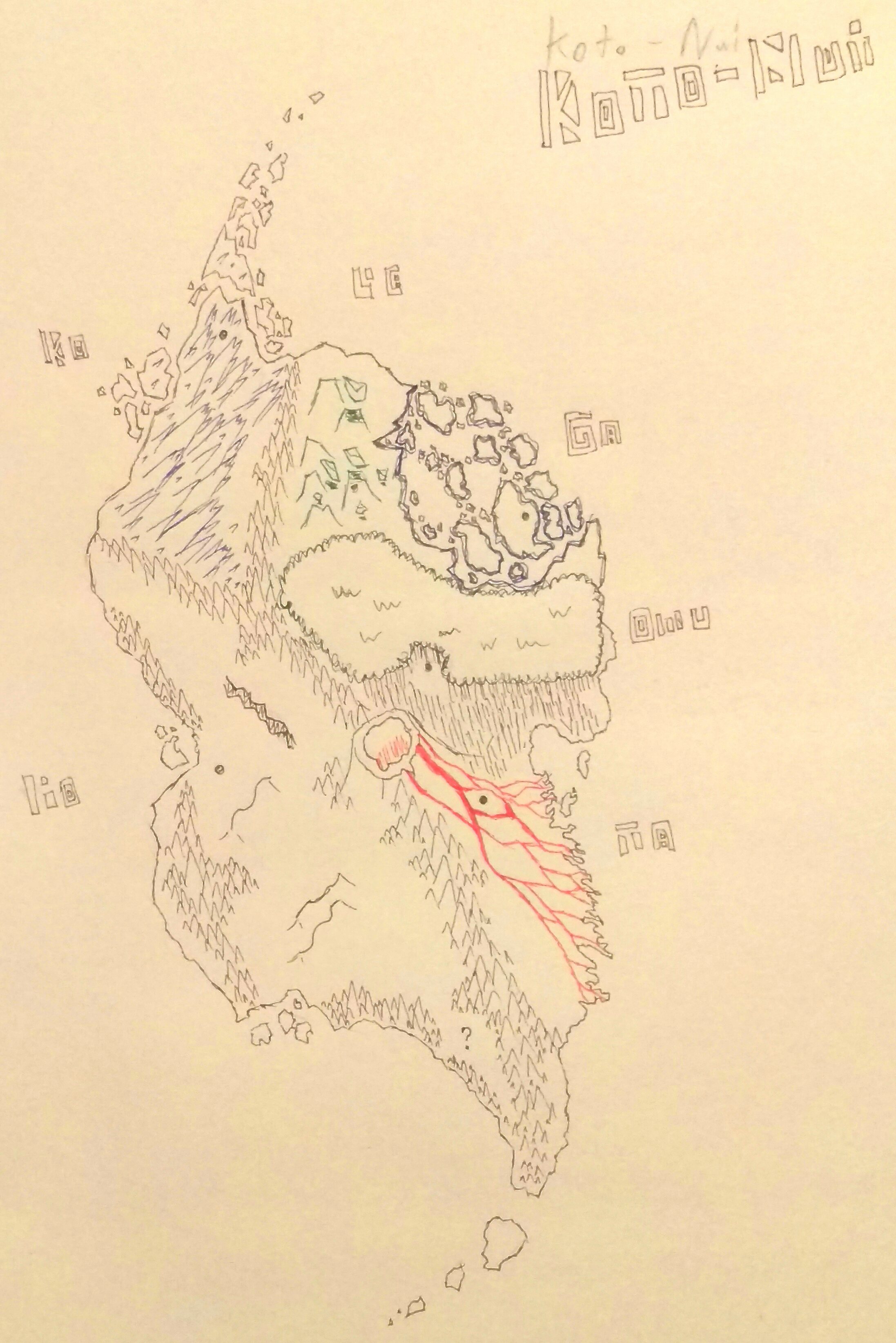
Concept art of the island paradise for g3.
So, discuss.
Interesting. Combines aspects of both Okoto and Mata Nui.
I’ll be honest, I was hoping more people would chime in, to spark some discussion on things like the regions geography and routes and the like, as the island itself is definitely a key part of bionicle.
And to be honest I really expected someone to point out how I totally stole copied @Oomatu 's region aesthetics.
Not half bad. I see the dots marked off of the page; can I ask if you think there should be just one village, like in G1, or multiple scattered across the island?
Personally, I’d lean towards a mix of the two, with many small villages, but one capital city for each region.
I feel like it would differ by region, ko and ta would probably only have capitals, with some very small villages close by, whereas ga and po would be littered with small villages and the capitals wouldn’t be as big as the others, I’m torn on le and onu personally, the dots mark approximately where the capitals would be located.
Interesting. Ko-Wahi only having one large settlement makes sense, since it is such a harsh environment, and I suppose that works for Ta-Koro as well (I see the Ta-Matoran as fairly militant anyway).
How big do you reckon the island should be? I personally am thinking a little more than a week’s journey from the top to the bottom, if you’re quick (so, about half the size of Italy I guess).
That was basically my reasoning.
I’m more leaning towards that being the trip from ko koro to ta koro, as it would make it more realistic that matoran wouldn’t explore the south of the island, which has multiple options for what could be there that I haven’t really decided on.
Ok, so about the size of Italy.
How come the lava runs on one side? If it’s an active volcano it should be spilling on all sides considering it has a round cone.
Good point, I think its because volcano aren’t necessarily symmetrical.
But he drew it with a round cone. If you want it to spill on only one side there has to be a dip on one of the volcano’s walls so lava spills out only that direction.
Vents? I just drew a generic volcano shape to represent there being a volcano there in the same way I only drew 3 dunes in po-wahi,
I’m sorry the inaccuracy bothered you. If someone paints a photographic version of this I’ll be sure that they make the volcano accurate.
I like what you have created, just a question and a reply. Is this based on any geographic accuracy? If so, I am interested to know, since I enjoy geography and maps a lot.
Po-wahi seems to be a lot bigger than the rest, like one third of the island. The other elements seem to be pressed against each other in the North-East. Is this intentional?
However, great work, I would have no problem (except for Po-wahi’s size) if this turned out to be a new Bionicle island.
I tried to keep things feeling bionicle but I specifically put ko wahi furthest north with the top spiral actually being a massive ice field rather than actual islands, and deserts are almost always surrounded by mountains, and the land of ta wahi is almost entirely volcanic rock from the lava flows, as you can see from the shoreline.
Absolutely, twofold, it adds to the general unrest of the tribes relations between each other, and it allows for the po-wahi raiders that have been thrown around. And given the locations of the koro the lower half of the desert would be uninhabited, which would leave it open for story advancement.