@UltimateMustacheX: I remember hearing from the TTV that it would take about two weeks to travel from the two farthest points of the island (correct me if I’m wrong). After doing some testing on a few maps, I’ve reached the conclusion that the island should be about 50% larger regarding distances. I’m not taking landscape into account, only distance.
Based on your measurement for Artakha, it would be roughly the same distance between San Diego and the Navajo Nation Reservation in Arizona (Artakha’s ~607 mi to the map’s ~632 mi). On foot, without rest, it would take roughly 7-9 days to travel.
I picked the distances based on that same 2 weeks for the total. Going on foot (3.1 mph) at about 14 hrs per day for 2 weeks gives the amount I have for the total. (This is the tip of Mangai to the tip of Naho). They have to have some time in there for resting/sleeping/eating/etc. so it wouldn’t be a full 24 hrs each day.
Each individual region was found using a ratio. The ratio of total inches of the island to its distance in miles is equal to the ratio of each region inches to x miles. Solving for x gives each of the region distances I have.
Ihu boarders are protected by a giant Ice Wall, like in Game of Thrones, but in this case to protect the region from both of the most hottest regions. The King of Ihu has numerous lords under him that swear their loyalty to him, many nouble houses. The wall is strongest and EXTRA THICC at the Mangai boarders, which is why its fall is even worse.
PS: It would make more sense if you write in that its square miles and kilometers when writing the size of all the regions.
The distances given are purely linear, for the longest straight line distance in each region (or tip to tip of the whole thing). Since finding the area of non geometric shapes like these are very time consuming and all around a pain to do, I didn’t bother calculating them.
You could just do grids for that (making each square a certain size) and then no one has to think too much about it. Like, maybe if each square was 10,000 sq mi?
Why the longest distance from one point to another for measuring the regions? Thats nkt really realiable or informative of the regions actual size. Square miles or kilometers is a standard used for any geograhical measurement of a territories size…specially since it adds the variable that the terrain wont be a perfect shape.
1 Like
It was to give some kind of reference. If you know the longest distance, you know the longest amount of time it will take to travel that region. Any other length would be less. I know that’s not the standard for geography, but it still works as a frame of reference, which was the purpose.
I never intended to give an actual area, since the exact shape of each region is subject to change. I just gave the longest span, since we have the canon idea of 2 weeks to walk from tip to tip.
I find it needlessly confusing when it doesnt factor in the terrain, if you fly or go by foot, or if there are man made obsticals that make traveling go by slower or faster.
1 Like
I mean, “as the crow flies” has been used for centuries. Its just to give people an idea of scale.
1 Like
In-world inaccuracy of that would work. But for us outside of it all, we could use something more precise cause we arent in that age and we do have the capabilities of knowing and crafting such precise measurements cause we have an outside perspective.
1 Like
Terrain/etc. are also subject to change. This is not the canon shape/terrain of the island, so going that in depth is pointless at this time.
This was made purely as a concept. So the canon 2 weeks to get from tip to tip was based on a straight, flat path, with a set speed and duration each day. It is enough to give an estimation for reference (this distance and rate of walking is equivalent to walking from the bottom point of Texas to the upper left corner of its northern border). Once the island becomes more established in the canon, then the adjustments can be made to properly measure everything out. Of course this means that the distances will go down to account for terrain/etc.
2 Likes
Hopefully they will aknowledge tour pitch and possibly incorporate it fully as the go to approach for the Island.
1 Like
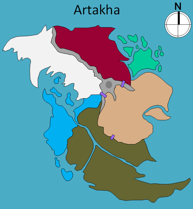
After hearing Brainstorm episode 5, the cast mentioned the volcano being more in the center of the island. I decided to redesign my previous concept to fit that detail as well. (The purple rectangles are the 3 merchant gates.)
5 Likes
I love this version. The old one seemed a bit too… Alien and hostile… I don’t know how to describe it, but it just felt too ‘unfriendly’ unlike Mata Nui. It just had that weird unnatural shape.
This however, seems fluid and elegant. I love it!
3 Likes
I kinda get what you mean, though I still kinda like it for that reason. But yes, I like this newer one much better. It seems more like a natural island shape with the regions piecing together better.
2 Likes
I like this one but the placement of Naho next to Ihu may cause some ice problems for the water region.
2 Likes
I see it more as the base of a rocky mountain along Naho’s border. The actual snow and ice would be higher up. Basically the warmer tropical region of Naho would prevent the ice from extending all the way to the mountain/cliff’s base.
2 Likes
That could work for most of the region but I think there would still be some sea ice and cold winds in northern Naho.
The northernmost Naho island is surrounded by Ihu and would probably be frozen at least.
1 Like
I wouldn’t say frozen. There’s way more water than ice there that comes from the warmer Naho. So, icy waters up there, sure. But not fully frozen. Probably just some floating ice chunks. The small island up there would definitely be colder than the others, but I doubt it would be Alaska island levels. The mix of warm and cold waters would make that island relatively neutral for temp.
If it were actually going to be more of a frozen over island, then it would probably be counted as Ihu territory instead.
[Edit] - Also, I can sort of see Nahoans making their boat huts to the west of the main Naho land mass (along that western curve). This would allow them to be more secluded from other regions. Then they use the bay and inner islands for specific goods in that spot or for accessing the river into Tiro for trading. So even if the bay was a bit more frozen over, then it wouldn’t necessarily affect the Nahoans.
2 Likes